© Roman Eisele / Wikimedia Commons / CC BY-SA 4.0
.

On this page, you will find a collection of links to scientific publications that are relevant to this project or that can contribute to a deeper exemplary understanding of the processes and circumstances that may be related to the Reinterpretation of Germania Magna presented here. These publications span different research areas.

The collection includes:

  • Primary literature: Scientific publications presenting the results of new research.
  • Secondary literature: Scientific publications summarizing, analyzing, or interpreting primary literature.
  • Comparative literature: Publications that exemplify similar processes and circumstances in other contexts.
  • Additional resources: Links to websites, databases, and other resources that may be relevant to the reinterpretation

The following publications are intended to help answer specific questions exemplarily, which may be related to the necessary processes and events required for extensive landscape transformation. These include considerations of tectonic fracture events and rift systems, with corresponding effects on maritime landslide events and the formation of new sedimentation basins.


The Chiemgau Meteorite Impact Strewn Field and the Digital Terrain Model: “Earthquake” Liquefaction from Above and from Below


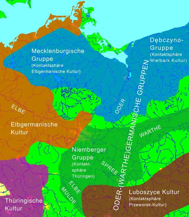
Fig. 1. Location map for the Chiemgau impact region. Published in 2019 Cosmic collision in prehistory The Chiemgau Impact : research in a Bavarian meteorite crater strewn field, M. RappenglückB. RappenglückK. Ernstson

DOI http://dx.doi.org/10.13140/RG.2.2.11274.79041 Abstract The Chiemgau strewn field discovered and established in the early new millennium(Schryvers and Raeymaekers, 2004; Schüssler et al., 2005; Rösler et al. 2005, Rappenglück,M. et al., 2005, Hoffmann et al., 2005, 2006; Yang et al 2008), extensively investigated in thefollowing decade until today (Ernstson et al. 2010, 2011, 2012, 2013, 2014, 2017, 2020, 2023,2024, Hiltl et al. 2011, Isaenko et al. 2012, Rappenglück, B. et al. 2010, 2020 a, b, c, 2021,Rappenglück M.A, et al. 2013, 2014, Bauer et al. 2013, 2019, 2020, Shumilova et al. 2018,Ernstson and Poßekel 2017, 2020 a, b, 2024, Ernstson and Shumilova 2020, Poßekel andErnstson 2019, 2020), and dated to 900-600 BC in the Bronze Age/Iron Age (Rappenglück, B.et al. 2023) comprises far more than 100 mostly rimmed craters scattered in a region of about60 km length and ca. 30 km width in the very South-East of Germany. The crater diametersrange between … Read moreThe Chiemgau Meteorite Impact Strewn Field and the Digital Terrain Model: “Earthquake” Liquefaction from Above and from Below
Neues zur „Odergermanischen Gruppe“: Das innere Barbaricum an der unteren Oder im 5.–6. Jh. AD


Volkmann, Armin. (2013). Neues zur „Odergermanischen Gruppe“: Das innere Barbaricum an der unteren Oder im 5.–6. Jh. AD., https://doi.org/10.11588/heidok.00015918

DOI https://doi.org/10.11588/heidok.00015918 Abstract In the early Migration Period (Period D), the climate worsened dramatically and weather became very cool and dry in the course of only a few decades. Very poor conditions for land cultivation and animal husbandry resulted from this, which withdrew their livelihood in many places from the Germanic groups engaged in subsistence agriculture. On this limited scale, this could be buffered by more intensive trade, like the piled material found on the site and documented by geomorphology on the aforementioned trade and transit routes Settlements in micro regional favoured areas with a guaranteed supply of water such as kettle lakes, for example, could continue to exist. Spatial analysis of settlements shows a strong shrinking of the settlement clusters to remaining areas in which agricultural activity was still possible. Thus, there is a great disparity of a juxtaposition of extremely unequal small scale economic potential, which led to … Read moreNeues zur „Odergermanischen Gruppe“: Das innere Barbaricum an der unteren Oder im 5.–6. Jh. AD

Herrschaftswechsel als Zäsur? Thüringen im Frankenreich – eine andere Geschichte


Bemmann, Jan. "Herrschaftswechsel als Zäsur? Thüringen im Frankenreich – eine andere Geschichte". Die Dukate des Merowingerreiches: Archäologie und Geschichte in vergleichender Perspektive, edited by Sebastian Brather, Berlin, Boston: De Gruyter, 2023, pp. 421-458. https://doi.org/10.1515/9783111128818-014

DOI https://doi.org/10.1515/9783111128818-014 Abstract Der Band analysiert in enger interdisziplinärer Debatte von Archäologen und Historikern die Dukate des Merowingerreiches einschließlich ihrer möglichen spätantiken Vorläufer. Ziel ist ein systematischer Vergleich von duces und Dukaten innerhalb des Frankenreiches des 6. bis 8. Jahrhunderts sowie weiterer ausgewählter Beispiele. Dabei wird jeweils nach Zeitpunkt, Voraussetzungen und Umständen ihrer Entstehung sowie nach der politischen Struktur und ihrer Entwicklung während der jüngeren Merowingerzeit gefragt. Besonderes Interesse beanspruchen einerseits Aufgaben der duces in Militär und Administration, Gesetzgebung und Rechtsprechung sowie andererseits Folgewirkungen in den Bereichen Kultur und Religion. Mit dem althistorischen bzw. mediävistischen Ausgangspunkt eröffnen sich vielfältige archäologische Perspektiven. Denn die zu rekonstruierenden politik- und verwaltungsgeschichtlichen Kontexte bieten Ansatzpunkte für neue Interpretationen jenseits des ‚ethnischen Paradigmas‘ bei der Interpretation archäologischer Befunde, und sie wirken mit ihren Raumanalysen zurück auf das geschichtswissenschaftliche Verständnis von duces und Dukaten. Im Folgenden gehe ich möglichen oder postulierten kulturellen Veränderungen in Mitteldeutschland nach, die mit der Eingliederung Thüringens in … Read moreHerrschaftswechsel als Zäsur? Thüringen im Frankenreich – eine andere Geschichte

Additional Notes on the Geography of Germania Magna


Sven Mildner - Neuinterpretation der Germania Magna des Claudius Ptolemy - EVROPA TABVLA QVARTA – Quarta Europe Tabula continet Germaniam cum insulis sibi adiacentibus. Die Karte zu ''Magna Germania'' aus der im Original griechisch verfaßten ''Geographike Hyphegesis'' des in Alexandria wirkenden Claudius Ptolemaios

a. Note on the term “Vistula Fluvius”: It is possible that the Greek term Οὐστούλα (Oustoúla) was originally adopted from Latin (i.e., by the Romans), with even older roots potentially found in the Celtic language or possibly that of the Jastorf Culture.In Latin, the word ustula is the imperative of ustulō and means “to burn something,” “to scorch something,” or also “to consume something with fire” – here to be understood as an order to someone or something to char or smolder something. There is probably also a closer connection to metalworking (especially charcoal burning), which is particularly indicated by the English cognate “ustulate” – as an adjective meaning “blackened” or “burnt” (Blackened as if burned) and as a verb directly referring to the “burning or roasting of ores” (actually two different processes). The naming of the river likely referred originally to the smoldering of wood, or directly to the … Read moreAdditional Notes on the Geography of Germania Magna