© Roman Eisele / Wikimedia Commons / CC BY-SA 4.0
.

On this page, you will find a collection of links to scientific publications that are relevant to this project or that can contribute to a deeper exemplary understanding of the processes and circumstances that may be related to the Reinterpretation of Germania Magna presented here. These publications span different research areas.

The collection includes:

  • Primary literature: Scientific publications presenting the results of new research.
  • Secondary literature: Scientific publications summarizing, analyzing, or interpreting primary literature.
  • Comparative literature: Publications that exemplify similar processes and circumstances in other contexts.
  • Additional resources: Links to websites, databases, and other resources that may be relevant to the reinterpretation

The following publications are intended to help answer specific questions exemplarily, which may be related to the necessary processes and events required for extensive landscape transformation. These include considerations of tectonic fracture events and rift systems, with corresponding effects on maritime landslide events and the formation of new sedimentation basins.


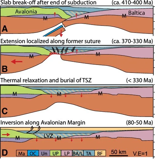
The Thor suture zone: From subduction to intraplate basin setting


Smit, Jeroen & Van Wees, J. & Cloetingh, Sierd. (2016). The Thor suture zone: From subduction to intraplate basin setting. Geology. 44. G37958.1. 10.1130/G37958.1.

DOI http://dx.doi.org/10.1130/G37958.1 Abstract The crustal seismic velocity structure of northwestern Europe shows a low P-wave velocity zone (LVZ) in the lower crust along the Caledonian Thor suture zone (TSZ) that cannot be easily attributed to Avalonia or Baltica plates abutting the TSZ. The LVZ appears to correspond to a hitherto unrecognized crustal segment (accretionary complex) that separates Avalonia from Baltica, explaining well the absence of Avalonia further east. Consequently, the northern boundary of Avalonia is shifted ∼150 km southward. Our interpretation, based on analysis of deep seismic profiles, places the LVZ in a consistent crustal domain interpretation. A comparison with present-day examples of the Kuril and Cascadia subduction zones suggests that the LVZ separating Avalonia from Baltica is composed of remnants of the Caledonian accretionary complex. If so, the present-day geometry probably originates from pre-Variscan extension and eduction during Devonian–Carboniferous backarc extension. The reinterpretation of deep crustal zonation provides a … Read moreThe Thor suture zone: From subduction to intraplate basin setting

Fault system evolution in the Baltic Sea area west of Rügen, NE Germany


Deutschmann, Andre & Meschede, Martin & Obst, Karsten. (2018). Fault system evolution in the Baltic Sea area west of Rügen, NE Germany. Geological Society, London, Special Publications. 469. SP469.24. 10.1144/SP469.24.

DOI https://doi.org/10.1144/sp469.24 Abstract Based on reprocessed offshore seismic lines acquired during oil and gas exploration in the 1980s, we reconstruct the formation and reactivation of major fault systems in the southern Baltic Sea area since the late Paleozoic. The geological evolution of different crustal blocks from the Caledonian Avalonia-Baltica collision until the Late Cretaceous-Paleogene inversion tectonics is also examined. The detected fault systems occur in the northern part of the Trans-European Suture Zone (TESZ) and belong either to the late Paleozoic Tornquist Fan or to the complex Western Pomeranian Fault System (WPFS) generated during Mesozoic extensional movements. While the NW- SE-trending deep Wiek Fault separates the Arkona High from the Middle Rügen Block, the NNW-SSE-trending Agricola Fault demarcates the Middle Rügen Block to the Falster Block in the west. Together with the Plantagenet Fault and numerous younger faults in the Mesozoic cover, it forms the Agricola Fault System. Furthermore, structural … Read moreFault system evolution in the Baltic Sea area west of Rügen, NE Germany

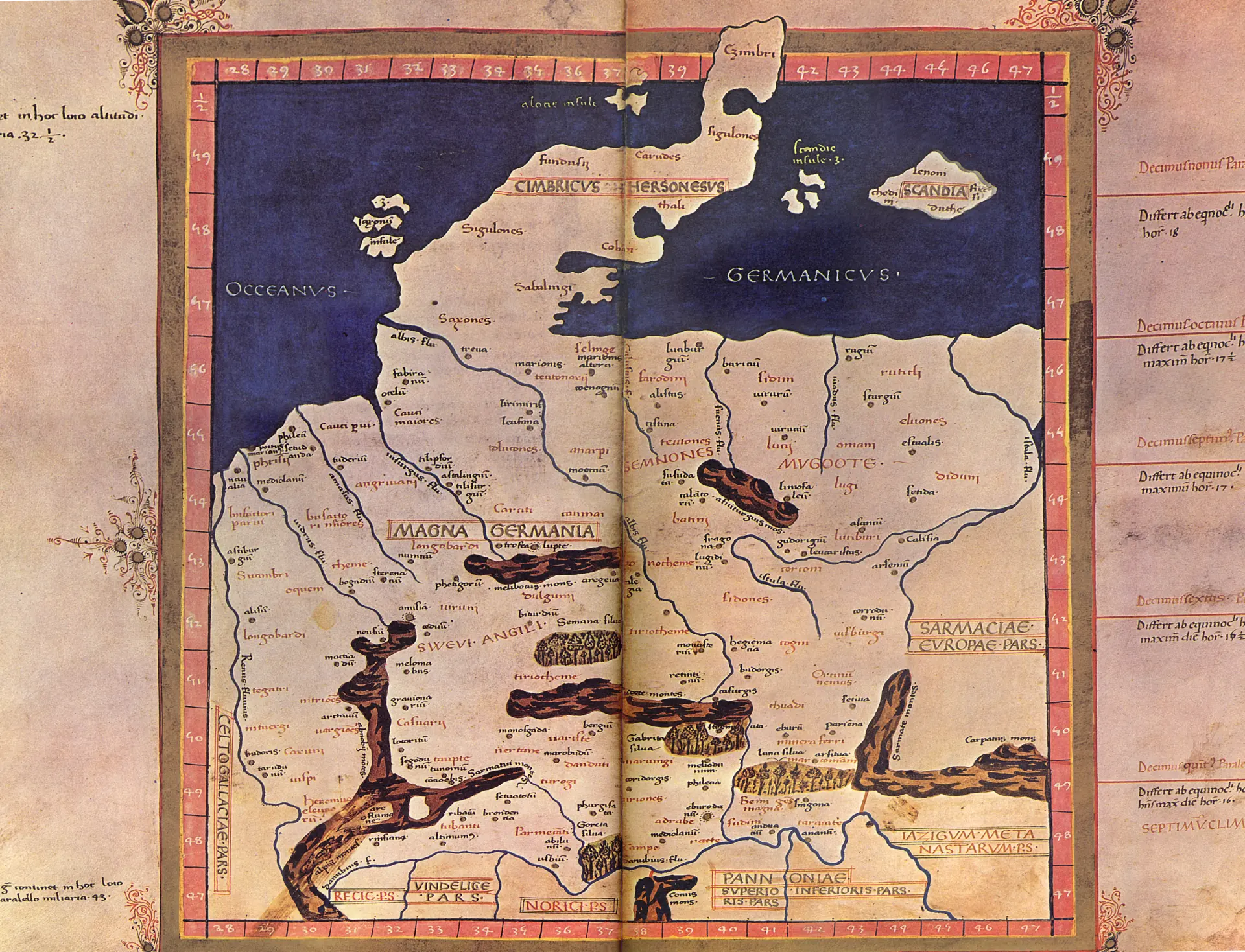
The Reinterpretation of Claudius Ptolemy’s Germania Magna by Sven Mildner


Sven Mildner - Neuinterpretation der Germania Magna des Claudius Ptolemy - EVROPA TABVLA QVARTA – Quarta Europe Tabula continet Germaniam cum insulis sibi adiacentibus. Die Karte zu ''Magna Germania'' aus der im Original griechisch verfaßten ''Geographike Hyphegesis'' des in Alexandria wirkenden Claudius Ptolemaios

DOI https://dx.doi.org/10.23689/fidgeo-5907 Sven Mildner https://orcid.org/0009-0005-8248-4866 In his draft for the Reinterpretation of Claudius Ptolemy’s Germania Magna – using computer-aided distortion analysis of a medieval map representation by Donnus Nicolaus Germanus – and considerations of post-glacial geodynamics of Europe, the author describes his assumption that Germania Magna underwent a far more extensive landscape transformation in geologically recent times than previously assumed. This transformation may have been caused by post-glacial land uplift in the Holocene or potentially by a reactivation of the Caledonian Deformation Front (CDF) during a late activity phase of the Alpine orogeny, accompanied by tectonic activities in the upper Earth’s crust. Additionally, the possibility that a cosmic impact event triggered such a reactivation of the CDF is not excluded. The conditions expected to justify the described process likely align with hitherto misattributed or incorrectly dated large-scale fracturing events, which might have led to significant earthquakes in Central Europe over … Read moreThe Reinterpretation of Claudius Ptolemy’s Germania Magna by Sven Mildner

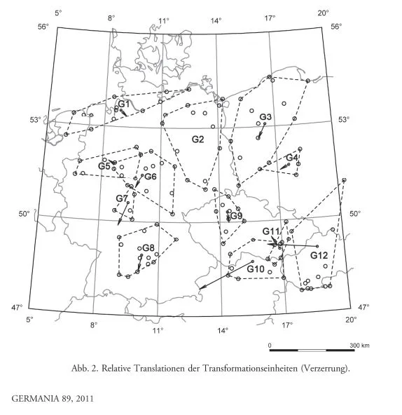
Germania magna – A new look at an old map: Rectifying Ptolemy’s geographical data for ancient places between the Rhine and the Vistula.


Nüsse, Hans-Jörg & Marx, Christian & Lelgemann, Dieter. (2011). Germania magna - A new look at an old map: Rectifying Ptolemy's geographical data for ancient places between the Rhine and the Vistula. Germania. 89. 115-155. https://doi.org/10.11588/ger.2011.96480

DOI https://doi.org/10.11588/ger.2011.96480 Abstract This paper deals with the geographical indications for Germania magna in the Geographike Hyphegisis (ca. AD 150) of Claudius Ptolemaeus. Previous attempts at the identification of Ptolemaic locations were neither comprehensive nor based on a qualified analysis of the ancient data. By means of the geodetic-statistical analytic method presented here, an appropriate study of the Ptolemaic coordinates in conjunction with the identification of almost all Ptolemaic landmarks in Germania magna could be performed for the first time. The results of the investigation are presented and examined for their archaeological significance; the archaeological-historical information contained in the Germania-map is extracted. Nüsse, Hans-Jörg & Marx, Christian & Lelgemann, Dieter. (2011). Germania magna – A new look at an old map: Rectifying Ptolemy’s geographical data for ancient places between the Rhine and the Vistula. Germania. 89. 115-155. https://doi.org/10.11588/ger.2011.96480