© Roman Eisele / Wikimedia Commons / CC BY-SA 4.0
.

On this page, you will find a collection of links to scientific publications that are relevant to this project or that can contribute to a deeper exemplary understanding of the processes and circumstances that may be related to the Reinterpretation of Germania Magna presented here. These publications span different research areas.

The collection includes:

  • Primary literature: Scientific publications presenting the results of new research.
  • Secondary literature: Scientific publications summarizing, analyzing, or interpreting primary literature.
  • Comparative literature: Publications that exemplify similar processes and circumstances in other contexts.
  • Additional resources: Links to websites, databases, and other resources that may be relevant to the reinterpretation

The following publications are intended to help answer specific questions exemplarily, which may be related to the necessary processes and events required for extensive landscape transformation. These include considerations of tectonic fracture events and rift systems, with corresponding effects on maritime landslide events and the formation of new sedimentation basins.


Sea-level change, glacial rebound and mantle viscosity for northern Europe


Kurt Lambeck, Catherine Smither, Paul Johnston, Sea-level change, glacial rebound and mantle viscosity for northern Europe, Geophysical Journal International, Volume 134, Issue 1, July 1998, Pages 102–144

DOI https://doi.org/10.1046/j.1365-246x.1998.00541.x Abstract Northwestern Europe remains a key region for testing models of glacial isostasy because of the good geological record of crustal response to the glacial unloading since the time of the Last Glacial Maximum. Models for this rebound and associated sea-level change require a detailed knowledge of the ice-sheet geometry, including the ice thickness through time. Existing ice-sheet reconstructions are strongly model-dependent, and inversions of sea-level data for the mantle response may be a function of the model assumptions. Thus inverse solutions for the sea-level data are sought that include both ice- and earth-model parameters as unknowns. Sea-level data from Fennoscandia, the North Sea, the British Isles and the Atlantic and English Channel coasts have been evaluated and incorporated into the solutions. The starting ice sheet for Fennoscandia is based on a reconstruction of a model by Denton & Hughes (1981) that is characterized by quasi-parabolic cross-sections and … Read moreSea-level change, glacial rebound and mantle viscosity for northern Europe

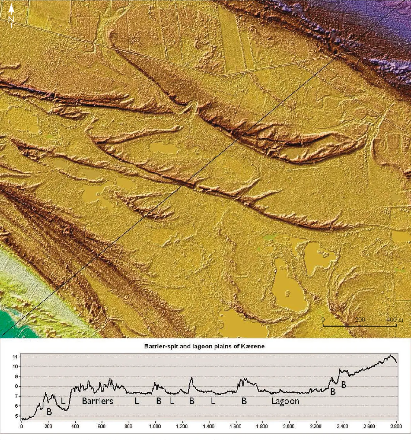
Continuous record of Holocene sea-level changes and coastal development of the Kattegat island Læsø (4900 years BP to present)


Hansen, Jens & Aagaard, Troels & Stockmarr, Jens & Møller, Ingelise & Nielsen, Lars & Binderup, Merete & Larsen, Jan & Larsen, Birger. (2016). Continuous record of Holocene sea-level changes and coastal development of the Kattegat island Læsø (4900 years BP to present). Bulletin of the Geological Society of Denmark. 64. 10.37570/bgsd-2016-64-01.

DOI http://dx.doi.org/10.37570/bgsd-2016-64-01 Læsø is the largest island of the Kattegat–Skagerrak region and exposes a vast array of relative sealevel (RSL) indicators, mainly raised beach ridges, swales, lagoons and saltmarshes. The physical environment of continuous glacial rebound, excessive supply of sediment, shallow surrounding waters, low amplitudes of near-shore waves, and micro-tidal conditions produced numerous sealevel proxies of both barrier coasts and saltmarshes. About 1200 RSL/age index points reflect not only short-term sea-level highstands as in most other parts of Europe, but also short-term sea-level lowstands, which in less regressive environments have normally been removed by coastal erosion or obscured by berms from subsequent highstands. Based on a high-precision lidar digital terrain model, the beach ridges have been mapped, typified, levelled and correlated relative to their order of appearance. Transformation of this relative chronology to a robust absolute age model of the RSL changes has been made on the basis of 119 … Read moreContinuous record of Holocene sea-level changes and coastal development of the Kattegat island Læsø (4900 years BP to present)

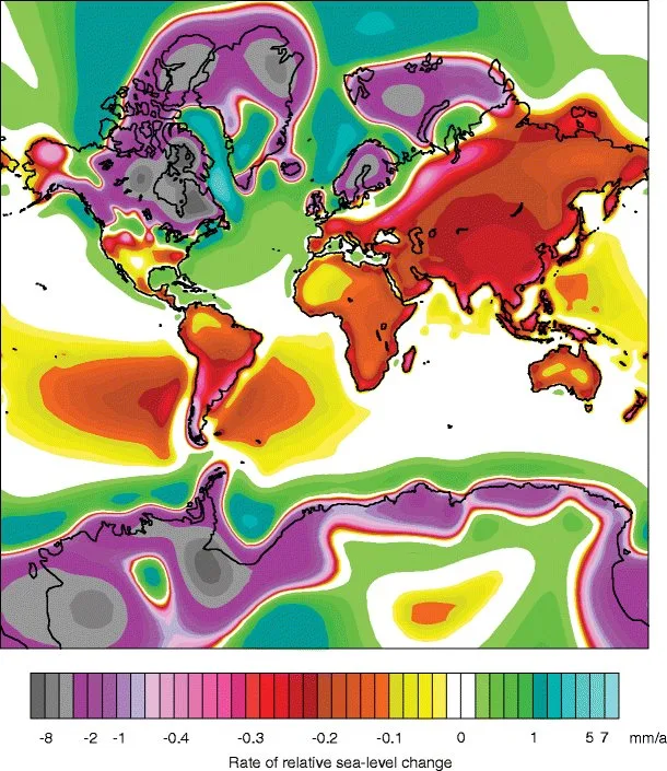
Holocene Relative Sea-Level Changes from Near-, Intermediate-, and Far-Field Locations


Khan, Nicole & Ashe, Erica & Shaw, Timothy & Vacchi, Matteo & Walker, Jennifer & Peltier, W. & Kopp, Robert & Horton, Benjamin. (2015). Holocene Relative Sea-Level Changes from Near-, Intermediate-, and Far-Field Locations. Current Climate Change Reports. 1. 10.1007/s40641-015-0029-z.

DOI https://dx.doi.org/10.1007/s40641-015-0029-z Abstract Holocene relative sea-level (RSL) records exhibit spatial and temporal variability that arises mainly from the interaction of eustatic (land ice volume and thermal expansion) and isostatic (glacio- and hydro-) factors. We fit RSL histories from near-, intermediate-, and far-field locations with noisy-input Gaussian process models to assess rates of RSL change. Records from near-field regions (e.g., Antarctica, Greenland, Canada, Sweden, and Scotland) reveal a complex pattern of RSL fall from a maximum marine limit due to the net effect of eustatic sea-level rise and glacio-isostatic uplift with rates of RSL fall as great as −69 ± 9 m/ka. Intermediate-field regions (e.g., mid-Atlantic and Pacific coasts of the USA, Netherlands, Southern France, St. Croix) display variable rates of RSL rise from the cumulative effect of eustatic and isostatic factors. Fast rates of RSL rise (up to 10 ± 1 m/ka) are found in the early Holocene in regions … Read moreHolocene Relative Sea-Level Changes from Near-, Intermediate-, and Far-Field Locations