© Roman Eisele / Wikimedia Commons / CC BY-SA 4.0
.

Auf dieser Seite finden Sie eine Sammlung von Links zu wissenschaftlichen Veröffentlichungen, die für dieses Projekt relevant sind oder die dazu beitragen können, ein tieferes exemplarisches Verständnis über die Prozesse und Umstände zu erlangen, welche möglicherweise in einem Zusammenhang mit der hier vorgestellten Neuinterpretation der Germania Magna stehen. Dabei handelt es sich um Veröffentlichungen unterschiedlicher Forschungsbereiche.

Die Sammlung umfasst:

  • Primärliteratur: Wissenschaftliche Veröffentlichungen, die die Ergebnisse neuer Forschung präsentieren.
  • Sekundärliteratur: Wissenschaftliche Veröffentlichungen, die die Primärliteratur zusammenfassen, analysieren oder interpretieren.
  • Vergleichende Literatur: Veröffentlichungen, die Ihnen exemplarisch ähnliche Prozesse und Umstände in anderen Kontexten aufzeigen.
  • Weitere Ressourcen: Links zu Websites, Datenbanken und anderen Ressourcen, die für die Neuinterpretation relevant sein können.

Die folgenden Publikationen sollen dabei helfen, bestimmte Fragestellungen exemplarisch zu beantworten, welche in einem möglichen Zusammenhang mit den notwendigen Prozessen und Vorgängen stehen, die für eine umfangreiche Landschaftstransformation erforderlich sind. Hierzu zählen beispielsweise Überlegungen über tektonische Bruchereignisse und Rift-Systeme, mit entsprechender Auswirkung auf maritime Rutschungsereignisse und die Entstehung neuer Sedimentationsbecken.


A new tectonic model for the Laurentia-Avalonia-Baltica sutures in the North Sea: A case study along MONA LISA profile 3


Lyngsie, S.B. & Thybo, H.. (2007). A new tectonic model for the Laurentia−Avalonia−Baltica sutures in the North Sea: A case study along MONA LISA profile 3. Tectonophysics. 429. 201-227. 10.1016/j.tecto.2006.09.017.

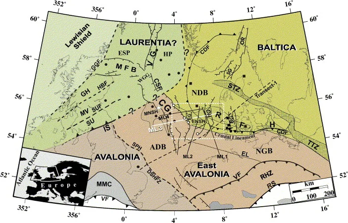
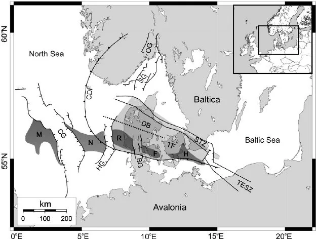
DOI http://dx.doi.org/10.1016/j.tecto.2006.09.017 Abstract We present a new model for the lithospheric structure of the transitions between Laurentia, Avalonia and Baltica in the North Sea, northwestern Europe based on 2¾D potential field modelling of MONA LISA profile 3 across the Central Graben, with constraints from seismic P-wave velocity models and the crustal normal incidence reflection section along the profile. The model shows evidence for the presence of upper-and lower Palaeozoic sedimentary rocks as well as differences in crustal structure between the palaeo-continents Laurentia, Avalonia and Baltica. Our new model, together with previous results from transformations of the gravity and magnetic fields, demonstrates correlation between crustal magnetic domains along the profile and the terrane affinity of the crust. This integrated interpretation indicates that a 150 km wide zone, characterized by low-grade metamorphosis and oblique thrusting of Avalonia crust over Baltica lower crust, is characteristic for the central North Sea area. The magnetic … WeiterlesenA new tectonic model for the Laurentia-Avalonia-Baltica sutures in the North Sea: A case study along MONA LISA profile 3

Seismic velocity structure of crustal intrusions in the Danish Basin


Simpli fi ed map of the main tectonic features in the Danish Basin and surrounding areas. Abbreviations: CDF = Caledonian Deformation Front; STZ = Sorgenfrei-Tornquist Zone; TF = Tornquist Fan (light grey); MNRFH = Mid North Sea-Ringkøbing-Fyn High; TESZ = Trans-European Suture Zone; DB = Danish Basin; CG = Central Graben; HG = Horn Graben; BG = Brande Graben; OG = Oslo Graben; SG = Skagerrak Graben. Inset shows location of study area in Europe. After Berthelsen (1992), MONA LISA Working Group (1997b) and Ziegler (1990).

DOI https://doi.org/10.1016/j.tecto.2011.11.019 We image the east- and westward extent of a crustal high-velocity body, the thickness of a layered sequence around the Moho at the flank of the body, and the uppermost mantle velocity along the 320 km long refraction and wide-angle reflection seismic profile ESTRID 2007 in the Danish Basin. Ray-tracing modelling of the seismic data reveals a high-velocity body (6.7-7.7 km/s between 10 and 30 km depth) with a lateral extent of at least 110 km. It is interpreted as an intrusive body of gabbroic composition. Moho depth is variable between 30 and 35 km along the profile. The crust is thin in a similar to 180 km wide zone approximately below the western part of the intrusive body and further westward in the basin area. The Pn velocity in the uppermost mantle is relatively low (similar to 7.8 km/s) beneath the thin crust whereas higher Pn velocities … WeiterlesenSeismic velocity structure of crustal intrusions in the Danish Basin

Mechanism for the Uplift of Gongga Shan in the Southeastern Tibetan Plateau Constrained by 3D Magnetotelluric Data


Jiang, Feng & Chen, Xiaobin & Unsworth, Martyn & Cai, Juntao & Han, Bing & Wang, Lifeng & Dong, Zeyi & Tengfa, Cui & Zhan, Yan & Zhao, Guoze & Tang, Ji. (2022). Mechanism for the Uplift of Gongga Shan in the Southeastern Tibetan Plateau Constrained by 3D Magnetotelluric Data. Geophysical Research Letters. 49. 10.1029/2021GL097394.

DOI http://dx.doi.org/10.1029/2021GL097394 Abstract Plain Language Summary Continent‐continent collisions are an important tectonic process and have controlled the formation of the modern continents. The India‐Asia collision is the best modern example and has produced both a high elevation plateau and the world’s highest mountain belts. A range of tectonic processes occurs during these collisions as the crust deforms including extrusion and perhaps crustal flow. Within these collision zones, there are locations of especially rapid uplift that have not been explained with existing geodynamic models. This paper investigates this process through a study of Gongga Shan—a mountain on the eastern edge of the Tibetan Plateau, where uplift continues at a rate of 2–3 mm per year and has formed peaks greater than 7,500 m in elevation. 3D inversion of an array of magnetotelluric data has produced a well‐constrained crustal resistivity model for the GGS area. It reveals that the GGS crust is … WeiterlesenMechanism for the Uplift of Gongga Shan in the Southeastern Tibetan Plateau Constrained by 3D Magnetotelluric Data

Dynamics of Mid-Palaeocene North Atlantic rifting linked with European intra-plate deformations


Nielsen, S., Stephenson, R. & Thomsen, E. Dynamics of Mid-Palaeocene North Atlantic rifting linked with European intra-plate deformations. Nature 450, 1071–1074 (2007).

DOI https://doi.org/10.1038/nature06379 Abstract The process of continental break-up provides a large-scale experiment that can be used to test causal relations between plate tectonics and the dynamics of the Earth’s deep mantle1,2. Detailed diagnostic information on the timing and dynamics of such events, which are not resolved by plate kinematic reconstructions, can be obtained from the response of the interior of adjacent continental plates to stress changes generated by plate boundary processes. Here we demonstrate a causal relationship between North Atlantic continental rifting at ∼62 Myr ago and an abrupt change of the intra-plate deformation style in the adjacent European continent. The rifting involved a left-lateral displacement between the North American-Greenland plate and Eurasia, which initiated the observed pause in the relative convergence of Europe and Africa3. The associated stress change in the European continent was significant and explains the sudden termination of a ∼20-Myr-long contractional intra-plate deformation within Europe4, during the late Cretaceous … WeiterlesenDynamics of Mid-Palaeocene North Atlantic rifting linked with European intra-plate deformations

Sea-level change, glacial rebound and mantle viscosity for northern Europe


Kurt Lambeck, Catherine Smither, Paul Johnston, Sea-level change, glacial rebound and mantle viscosity for northern Europe, Geophysical Journal International, Volume 134, Issue 1, July 1998, Pages 102–144

Kurt Lambeck, Catherine Smither, Paul Johnston, Sea-level change, glacial rebound and mantle viscosity for northern Europe, Geophysical Journal International, Volume 134, Issue 1, July 1998, Pages 102–144

Continuous record of Holocene sea-level changes and coastal development of the Kattegat island Læsø (4900 years BP to present)


Hansen, Jens & Aagaard, Troels & Stockmarr, Jens & Møller, Ingelise & Nielsen, Lars & Binderup, Merete & Larsen, Jan & Larsen, Birger. (2016). Continuous record of Holocene sea-level changes and coastal development of the Kattegat island Læsø (4900 years BP to present). Bulletin of the Geological Society of Denmark. 64. 10.37570/bgsd-2016-64-01.

DOI http://dx.doi.org/10.37570/bgsd-2016-64-01 Læsø is the largest island of the Kattegat–Skagerrak region and exposes a vast array of relative sealevel (RSL) indicators, mainly raised beach ridges, swales, lagoons and saltmarshes. The physical environment of continuous glacial rebound, excessive supply of sediment, shallow surrounding waters, low amplitudes of near-shore waves, and micro-tidal conditions produced numerous sealevel proxies of both barrier coasts and saltmarshes. About 1200 RSL/age index points reflect not only short-term sea-level highstands as in most other parts of Europe, but also short-term sea-level lowstands, which in less regressive environments have normally been removed by coastal erosion or obscured by berms from subsequent highstands. Based on a high-precision lidar digital terrain model, the beach ridges have been mapped, typified, levelled and correlated relative to their order of appearance. Transformation of this relative chronology to a robust absolute age model of the RSL changes has been made on the basis of 119 … WeiterlesenContinuous record of Holocene sea-level changes and coastal development of the Kattegat island Læsø (4900 years BP to present)

Holocene Relative Sea-Level Changes from Near-, Intermediate-, and Far-Field Locations


Khan, Nicole & Ashe, Erica & Shaw, Timothy & Vacchi, Matteo & Walker, Jennifer & Peltier, W. & Kopp, Robert & Horton, Benjamin. (2015). Holocene Relative Sea-Level Changes from Near-, Intermediate-, and Far-Field Locations. Current Climate Change Reports. 1. 10.1007/s40641-015-0029-z.

DOI https://dx.doi.org/10.1007/s40641-015-0029-z Abstract Holocene relative sea-level (RSL) records exhibit spatial and temporal variability that arises mainly from the interaction of eustatic (land ice volume and thermal expansion) and isostatic (glacio- and hydro-) factors. We fit RSL histories from near-, intermediate-, and far-field locations with noisy-input Gaussian process models to assess rates of RSL change. Records from near-field regions (e.g., Antarctica, Greenland, Canada, Sweden, and Scotland) reveal a complex pattern of RSL fall from a maximum marine limit due to the net effect of eustatic sea-level rise and glacio-isostatic uplift with rates of RSL fall as great as −69 ± 9 m/ka. Intermediate-field regions (e.g., mid-Atlantic and Pacific coasts of the USA, Netherlands, Southern France, St. Croix) display variable rates of RSL rise from the cumulative effect of eustatic and isostatic factors. Fast rates of RSL rise (up to 10 ± 1 m/ka) are found in the early Holocene in regions … WeiterlesenHolocene Relative Sea-Level Changes from Near-, Intermediate-, and Far-Field Locations

The catastrophic final flooding of Doggerland by the Storegga Slide tsunami


Weninger, Bernhard & Schulting, Rick & Bradtmöller, Marcel & Clare, Lee & Collard, Mark & Edinborough, Kevan & Hilpert, Johanna & Jöris, Olaf & Niekus, Marcel & Rohling, Eelco & Wagner, Bernd. (2008). The catastrophic final flooding of Doggerland by the Storegga Slide tsunami. Documenta Praehistorica XXXV. 34426126. 10.4312/dp.35.1.

DOI https://doi.org/10.4312/dp.35.1 Abstract Around 8200 calBP, large parts of the now submerged North Sea continental shelf (‘Doggerland’) were catastrophically flooded by the Storegga Slide tsunami, one of the largest tsunamis known for the Holocene, which was generated on the Norwegian coastal margin by a submarine landslide. In the present paper, we derive a precise calendric date for the Storegga Slide tsunami, use this date for reconstruction of contemporary coastlines in the North Sea in relation to rapidly rising sea-levels, and discuss the potential effects of the tsunami on the contemporaneous Mesolithic population. One main result of this study is an unexpectedly high tsunami impact assigned to the western regions of Jutland. Weninger, B., Schulting, R., Bradtmöller, M., Clare, L., Collard, M., Edinborough, K., Hilpert, J., Jöris, O., Niekus, M., Rohling, E. J., & Wagner, B. (2008). The catastrophic final flooding of Doggerland by the Storegga Slide tsunami. Documenta Praehistorica, 35, 1-24. https://doi.org/10.4312/dp.35.1

Rapid Quaternary subsidence in the northwestern German North Sea


Arfai, Jashar & Franke, Dieter & Lutz, Rüdiger & Reinhardt, Lutz & Kley, Jonas & Gaedicke, Christoph. (2018). Rapid Quaternary subsidence in the northwestern German North Sea. Scientific Reports. 8. 10.1038/s41598-018-29638-6.

DOI https://doi.org/10.1038/s41598-018-29638-6 Abstract 3D and 2D seismic data reveal the base-reflection of the Quaternary in the northwestern German North Sea locally at depths of more than 1000 m. This indicates extremely fast subsidence, with a rate of up to 480 m/Ma during the Quaternary, resulting in a NNW-SSE oriented sedimentary depocentre. Distinct iceberg scour marks, identified in 3D seismic data are used to calibrate quantitative subsidence analysis and to document shallow marine conditions during the Quaternary interglacials. Previously, a number of mechanisms have been proposed to explain the Quaternary subsidence. Here we show that compaction and load-induced subsidence alone explain about 75% of the observed Quaternary subsidence. However, a certain portion of the subsidence needs additional processes to be invoked. The extensive seismic dataset interpreted here makes it possible to exclude a phase of renewed tectonic activity as the origin of the subsidence anomaly. From the orientation and extent of the depocentre, … WeiterlesenRapid Quaternary subsidence in the northwestern German North Sea

The Thor suture zone: From subduction to intraplate basin setting


Smit, Jeroen & Van Wees, J. & Cloetingh, Sierd. (2016). The Thor suture zone: From subduction to intraplate basin setting. Geology. 44. G37958.1. 10.1130/G37958.1.

DOI http://dx.doi.org/10.1130/G37958.1 Abstract The crustal seismic velocity structure of northwestern Europe shows a low P-wave velocity zone (LVZ) in the lower crust along the Caledonian Thor suture zone (TSZ) that cannot be easily attributed to Avalonia or Baltica plates abutting the TSZ. The LVZ appears to correspond to a hitherto unrecognized crustal segment (accretionary complex) that separates Avalonia from Baltica, explaining well the absence of Avalonia further east. Consequently, the northern boundary of Avalonia is shifted ∼150 km southward. Our interpretation, based on analysis of deep seismic profiles, places the LVZ in a consistent crustal domain interpretation. A comparison with present-day examples of the Kuril and Cascadia subduction zones suggests that the LVZ separating Avalonia from Baltica is composed of remnants of the Caledonian accretionary complex. If so, the present-day geometry probably originates from pre-Variscan extension and eduction during Devonian–Carboniferous backarc extension. The reinterpretation of deep crustal zonation provides a … WeiterlesenThe Thor suture zone: From subduction to intraplate basin setting