Auf dieser Seite finden Sie eine Sammlung von Links zu wissenschaftlichen Veröffentlichungen, die für dieses Projekt relevant sind oder die dazu beitragen können, ein tieferes exemplarisches Verständnis über die Prozesse und Umstände zu erlangen, welche möglicherweise in einem Zusammenhang mit der hier vorgestellten Neuinterpretation der Germania Magna stehen. Dabei handelt es sich um Veröffentlichungen unterschiedlicher Forschungsbereiche.
Die Sammlung umfasst:
Primärliteratur: Wissenschaftliche Veröffentlichungen, die die Ergebnisse neuer Forschung präsentieren.
Sekundärliteratur: Wissenschaftliche Veröffentlichungen, die die Primärliteratur zusammenfassen, analysieren oder interpretieren.
Vergleichende Literatur: Veröffentlichungen, die Ihnen exemplarisch ähnliche Prozesse und Umstände in anderen Kontexten aufzeigen.
Weitere Ressourcen: Links zu Websites, Datenbanken und anderen Ressourcen, die für die Neuinterpretation relevant sein können.
Die folgenden Publikationen sollen dabei helfen, bestimmte Fragestellungen exemplarisch zu beantworten, welche in einem möglichen Zusammenhang mit den notwendigen Prozessen und Vorgängen stehen, die für eine umfangreiche Landschaftstransformation erforderlich sind. Hierzu zählen beispielsweise Überlegungen über tektonische Bruchereignisse und Rift-Systeme, mit entsprechender Auswirkung auf maritime Rutschungsereignisse und die Entstehung neuer Sedimentationsbecken.
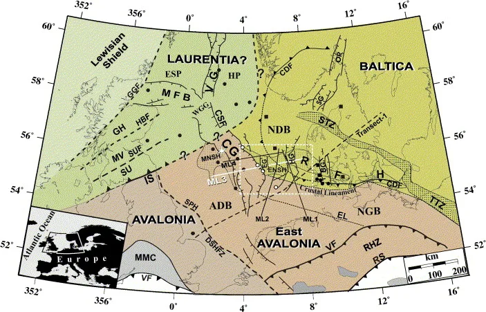
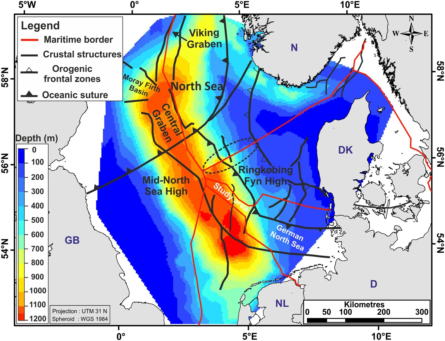
DOI http://dx.doi.org/10.1016/j.tecto.2006.09.017 Abstract We present a new model for the lithospheric structure of the transitions between Laurentia, Avalonia and Baltica in the North Sea, northwestern Europe based on 2¾D potential field modelling of MONA LISA profile 3 across the Central Graben, with constraints from seismic P-wave velocity models and the crustal normal incidence reflection section along the profile. The model shows evidence for the presence of upper-and lower Palaeozoic sedimentary rocks as well as differences in crustal structure between the palaeo-continents Laurentia, Avalonia and Baltica. Our new model, together with previous results from transformations of the gravity and magnetic fields, demonstrates correlation between crustal magnetic domains along the profile and the terrane affinity of the crust. This integrated interpretation indicates that a 150 km wide zone, characterized by low-grade metamorphosis and oblique thrusting of Avalonia crust over Baltica lower crust, is characteristic for the central North Sea area. The magnetic … WeiterlesenA new tectonic model for the Laurentia-Avalonia-Baltica sutures in the North Sea: A case study along MONA LISA profile 3
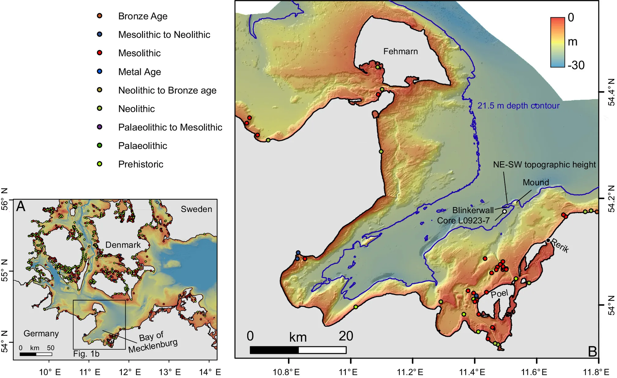
DOI https://doi.org/10.1073/pnas.2312008121 Abstract The Baltic Sea basins, some of which only submerged in the mid-Holocene, preserve Stone Age structures that did not survive on land. Yet, the discovery of these features is challenging and requires cross-disciplinary approaches between archeology and marine geosciences. Here, we combine shipborne and autonomousunderwater vehicle hydroacoustic data with up to a centimeter range resolution, sedimentological samples, and optical images to explore a Stone Age megastructure located in 21 m water depth in the Bay of Mecklenburg, Germany. The structure is made of 1,673 individual stones which are usually less than 1 m in height, placed side by side over a distance of 971 m in a way that argues against a natural origin by glacial transport or ice push ridges. Running adjacent to the sunken shoreline of a paleolake (or bog), whose youngest phase was dated to 9,143 ±36 ka B.P., the stonewall was likely used … WeiterlesenA submerged Stone Age hunting architecture from the Western Baltic Sea
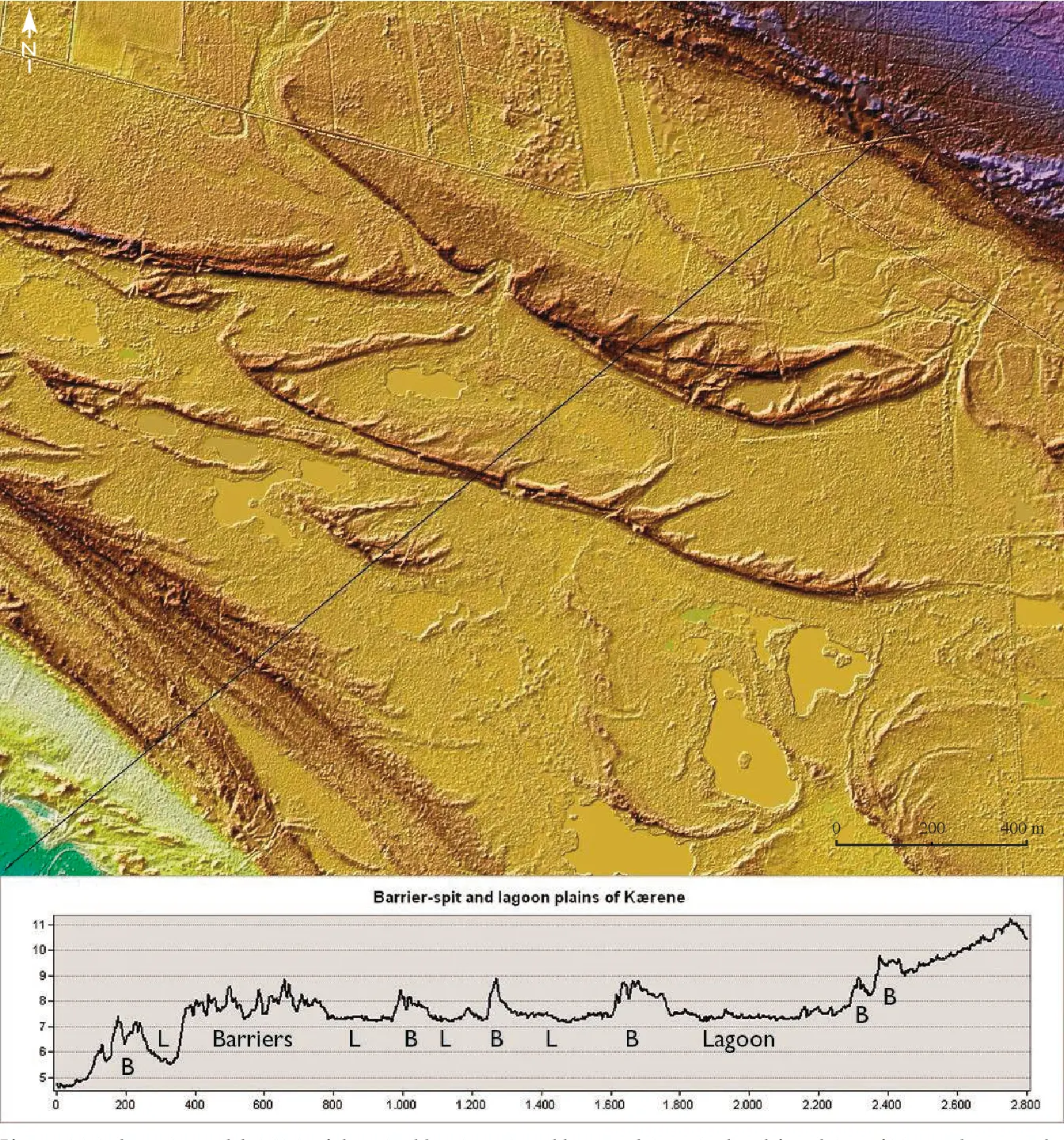
DOI http://dx.doi.org/10.37570/bgsd-2016-64-01 Læsø is the largest island of the Kattegat–Skagerrak region and exposes a vast array of relative sealevel (RSL) indicators, mainly raised beach ridges, swales, lagoons and saltmarshes. The physical environment of continuous glacial rebound, excessive supply of sediment, shallow surrounding waters, low amplitudes of near-shore waves, and micro-tidal conditions produced numerous sealevel proxies of both barrier coasts and saltmarshes. About 1200 RSL/age index points reflect not only short-term sea-level highstands as in most other parts of Europe, but also short-term sea-level lowstands, which in less regressive environments have normally been removed by coastal erosion or obscured by berms from subsequent highstands. Based on a high-precision lidar digital terrain model, the beach ridges have been mapped, typified, levelled and correlated relative to their order of appearance. Transformation of this relative chronology to a robust absolute age model of the RSL changes has been made on the basis of 119 … WeiterlesenContinuous record of Holocene sea-level changes and coastal development of the Kattegat island Læsø (4900 years BP to present)
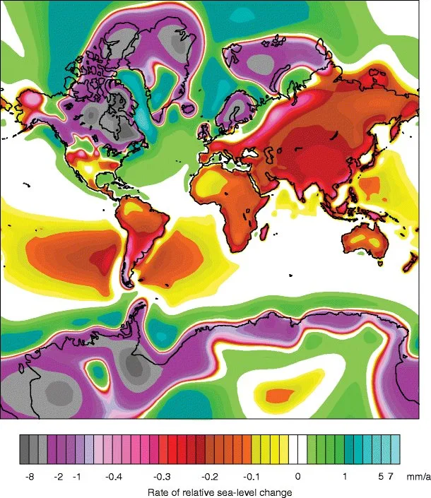
DOI https://dx.doi.org/10.1007/s40641-015-0029-z Abstract Holocene relative sea-level (RSL) records exhibit spatial and temporal variability that arises mainly from the interaction of eustatic (land ice volume and thermal expansion) and isostatic (glacio- and hydro-) factors. We fit RSL histories from near-, intermediate-, and far-field locations with noisy-input Gaussian process models to assess rates of RSL change. Records from near-field regions (e.g., Antarctica, Greenland, Canada, Sweden, and Scotland) reveal a complex pattern of RSL fall from a maximum marine limit due to the net effect of eustatic sea-level rise and glacio-isostatic uplift with rates of RSL fall as great as −69 ± 9 m/ka. Intermediate-field regions (e.g., mid-Atlantic and Pacific coasts of the USA, Netherlands, Southern France, St. Croix) display variable rates of RSL rise from the cumulative effect of eustatic and isostatic factors. Fast rates of RSL rise (up to 10 ± 1 m/ka) are found in the early Holocene in regions … WeiterlesenHolocene Relative Sea-Level Changes from Near-, Intermediate-, and Far-Field Locations
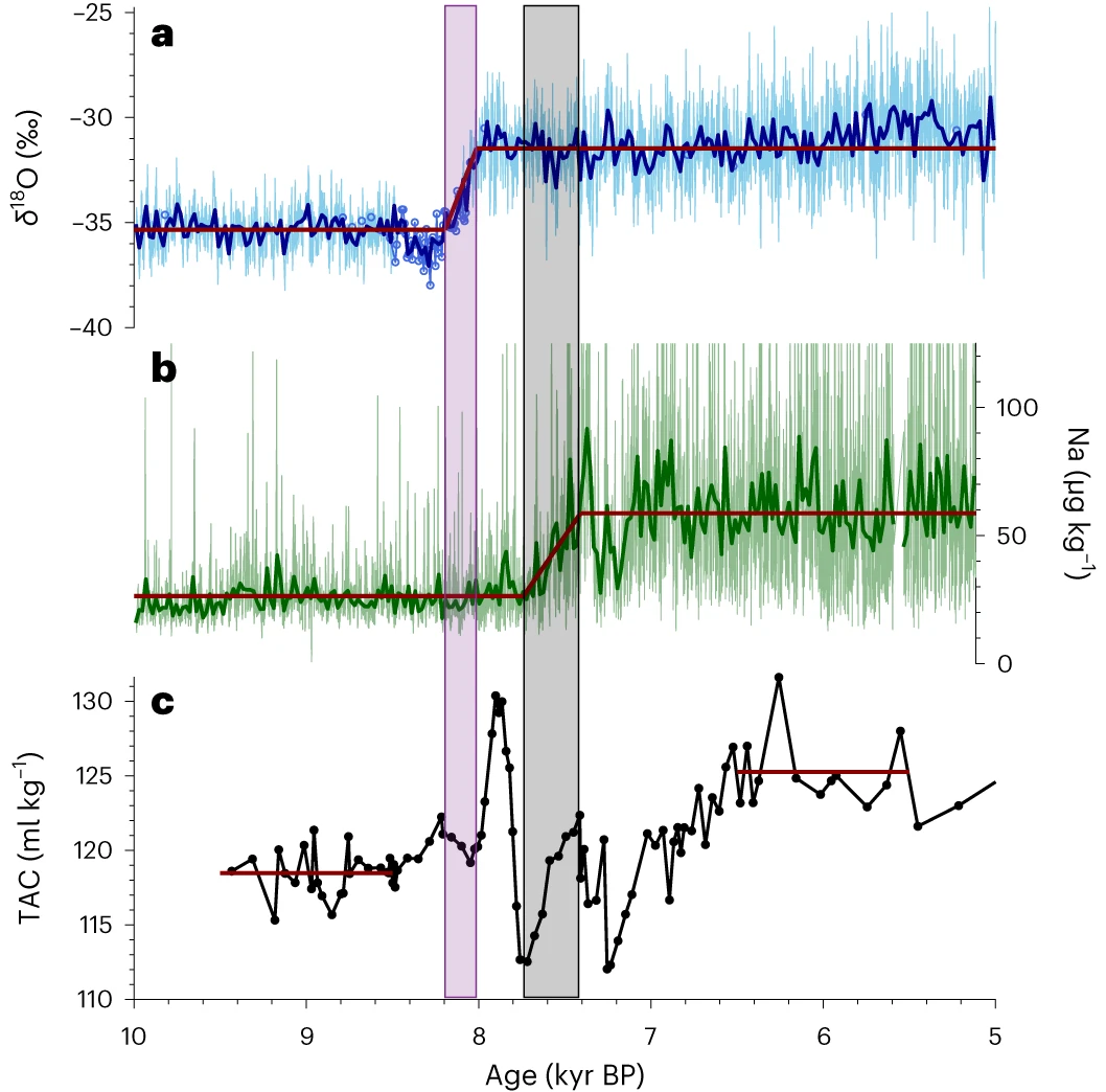
DOI https://doi.org/10.1038/s41561-024-01375-8 Abstract The extent of grounded ice and buttressing by the Ronne Ice Shelf, which provides resistance to the outflow of ice streams, moderate West Antarctic Ice Sheet stability. During the Last Glacial Maximum, the ice sheet advanced and was grounded near the Weddell Sea continental shelf break. The timing of subsequent ice sheet retreat and the relative roles of ice shelf buttressing and grounding line changes remain unresolved. Here we use an ice core record from grounded ice at Skytrain Ice Rise to constrain the timing and speed of early Holocene ice sheet retreat. Measured δ18O and total air content suggest that the surface elevation of Skytrain Ice Rise decreased by about 450 m between 8.2 and 8.0 kyr before 1950 CE (±0.13 kyr). We attribute this elevation change to dynamic thinning due to flow changes induced by the ungrounding of ice in the area. Ice core sodium concentrations suggest that the ice front … WeiterlesenAbrupt Holocene ice loss due to thinning and ungrounding in the Weddell Sea Embayment
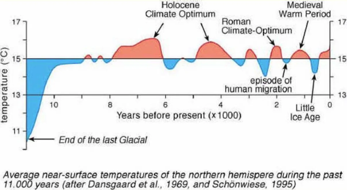
DOI http://dx.doi.org/10.1126/science.166.3903.377 Abstract A correlation of time with depth has been evaluated for the Camp Century, Greenland, 1390 meter deep ice core. Oxygen isotopes in approximately 1600 samples throughout the core have been analyzed. Long-term variations in the isotopic composition of the ice reflect the climatic changes during the past nearly 100,000 years. Climatic oscillations with periods of 120, 940, and 13,000 years are observed. W. Dansgaard et al., One Thousand Centuries of Climatic Record from Camp Century on the Greenland Ice Sheet. Science166, 377-381 (1969). DOI: 10.1126/science.166.3903.377
DOI https://doi.org/10.1038/s41598-018-29638-6 Abstract 3D and 2D seismic data reveal the base-reflection of the Quaternary in the northwestern German North Sea locally at depths of more than 1000 m. This indicates extremely fast subsidence, with a rate of up to 480 m/Ma during the Quaternary, resulting in a NNW-SSE oriented sedimentary depocentre. Distinct iceberg scour marks, identified in 3D seismic data are used to calibrate quantitative subsidence analysis and to document shallow marine conditions during the Quaternary interglacials. Previously, a number of mechanisms have been proposed to explain the Quaternary subsidence. Here we show that compaction and load-induced subsidence alone explain about 75% of the observed Quaternary subsidence. However, a certain portion of the subsidence needs additional processes to be invoked. The extensive seismic dataset interpreted here makes it possible to exclude a phase of renewed tectonic activity as the origin of the subsidence anomaly. From the orientation and extent of the depocentre, … WeiterlesenRapid Quaternary subsidence in the northwestern German North Sea