Auf dieser Seite finden Sie eine Sammlung von Links zu wissenschaftlichen Veröffentlichungen, die für dieses Projekt relevant sind oder die dazu beitragen können, ein tieferes exemplarisches Verständnis über die Prozesse und Umstände zu erlangen, welche möglicherweise in einem Zusammenhang mit der hier vorgestellten Neuinterpretation der Germania Magna stehen. Dabei handelt es sich um Veröffentlichungen unterschiedlicher Forschungsbereiche.
Die Sammlung umfasst:
Primärliteratur: Wissenschaftliche Veröffentlichungen, die die Ergebnisse neuer Forschung präsentieren.
Sekundärliteratur: Wissenschaftliche Veröffentlichungen, die die Primärliteratur zusammenfassen, analysieren oder interpretieren.
Vergleichende Literatur: Veröffentlichungen, die Ihnen exemplarisch ähnliche Prozesse und Umstände in anderen Kontexten aufzeigen.
Weitere Ressourcen: Links zu Websites, Datenbanken und anderen Ressourcen, die für die Neuinterpretation relevant sein können.
Die folgenden Publikationen sollen dabei helfen, bestimmte Fragestellungen exemplarisch zu beantworten, welche in einem möglichen Zusammenhang mit den notwendigen Prozessen und Vorgängen stehen, die für eine umfangreiche Landschaftstransformation erforderlich sind. Hierzu zählen beispielsweise Überlegungen über tektonische Bruchereignisse und Rift-Systeme, mit entsprechender Auswirkung auf maritime Rutschungsereignisse und die Entstehung neuer Sedimentationsbecken.
a. Anmerkung zur Bezeichnung “Vistula Fluvius”: Möglicherweise wurde die griechische Bezeichnung Οὐστούλα (Oustoúla) ursprünglich aus dem Lateinischen (also von den Römern) übernommen, könnte aber auch ältere Wurzeln in der keltischen Sprache haben oder gar in der Jastorf Kultur.Im Lateinischen ist das Wort ustula der Imperativ von ustulō und hat die Bedeutung “etwas verbrennen”, “etwas versengen” oder auch, “etwas mit Feuer verzehren” – hier aber als Aufforderung an jemanden oder etwas zu verstehen, er solle etwas ankokeln oder zum Schwelen bringen.Wahrscheinlich besteht hier auch ein engerer Zusammenhang mit der Metallgewinnung (speziell dem Köhlern), worauf insbesondere auch die englische Wortverwandtschaft mit ustulate hindeutet – als Adjektiv im Sinne von geschwärzt oder wie verbrannt (sein), und als Verb direkt auch zur Bezeichnung für das “Brennen oder Rösten von Erzen” (eigentlich zwei unterschiedliche Vorgänge). Die Benennung des Flusses bezog sich ursprünglich also sehr wahrscheinlich auf das Schwelen lassen von Holz, bzw. direkt auf das … WeiterlesenAnmerkungen zur Geografie der Germania Magna
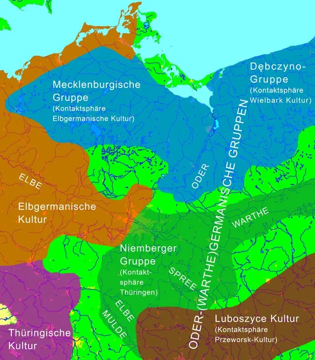
DOI https://doi.org/10.11588/heidok.00015918 Abstract In the early Migration Period (Period D), the climate worsened dramatically and weather became very cool and dry in the course of only a few decades. Very poor conditions for land cultivation and animal husbandry resulted from this, which withdrew their livelihood in many places from the Germanic groups engaged in subsistence agriculture. On this limited scale, this could be buffered by more intensive trade, like the piled material found on the site and documented by geomorphology on the aforementioned trade and transit routes Settlements in micro regional favoured areas with a guaranteed supply of water such as kettle lakes, for example, could continue to exist. Spatial analysis of settlements shows a strong shrinking of the settlement clusters to remaining areas in which agricultural activity was still possible. Thus, there is a great disparity of a juxtaposition of extremely unequal small scale economic potential, which led to … WeiterlesenNeues zur „Odergermanischen Gruppe“: Das innere Barbaricum an der unteren Oder im 5.–6. Jh. AD
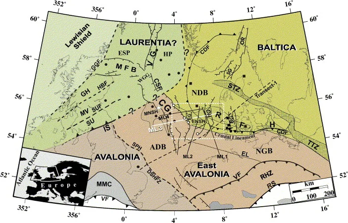
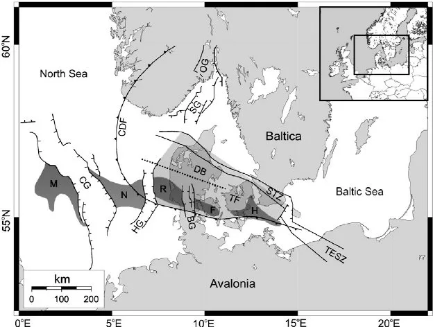
DOI http://dx.doi.org/10.1016/j.tecto.2006.09.017 Abstract We present a new model for the lithospheric structure of the transitions between Laurentia, Avalonia and Baltica in the North Sea, northwestern Europe based on 2¾D potential field modelling of MONA LISA profile 3 across the Central Graben, with constraints from seismic P-wave velocity models and the crustal normal incidence reflection section along the profile. The model shows evidence for the presence of upper-and lower Palaeozoic sedimentary rocks as well as differences in crustal structure between the palaeo-continents Laurentia, Avalonia and Baltica. Our new model, together with previous results from transformations of the gravity and magnetic fields, demonstrates correlation between crustal magnetic domains along the profile and the terrane affinity of the crust. This integrated interpretation indicates that a 150 km wide zone, characterized by low-grade metamorphosis and oblique thrusting of Avalonia crust over Baltica lower crust, is characteristic for the central North Sea area. The magnetic … WeiterlesenA new tectonic model for the Laurentia-Avalonia-Baltica sutures in the North Sea: A case study along MONA LISA profile 3
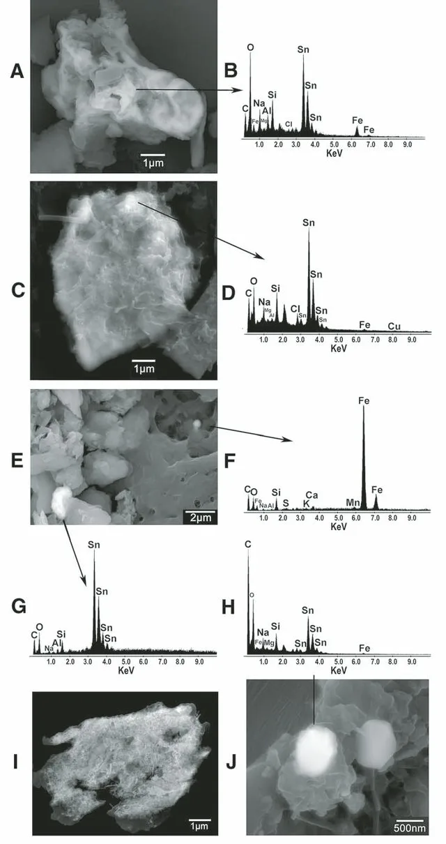
DOI https://doi.org/10.1130/2014.2505(23) Abstract Sn-rich particles, Ni-rich particles, and cosmic spherules are found together at four discrete stratigraphic levels within the 362–360 m depth interval of the Greenland Ice Sheet Project 2 (GISP2) ice core (72.6°N, 38.5°W, elevation: 3203 m). Using a previously derived calendar-year time scale, these particles span a time of increased dust loading of Earth’s atmosphere between A.D. 533 and 540. The Sn-rich and Ni-rich particles contain an average of 10–11 wt% C. Their high C contents coupled with local enrichments in the volatile elements I, Zn, Cu, and Xe suggest a cometary source for the dust. The late spring timing of extraterrestrial input best matches the Eta Aquarid meteor shower associated with comet 1P/Halley. An increased flux of cometary dust might explain a modest climate downturn in A.D. 533. Both cometary dust and volcanic sulfate probably contributed to the profound global dimming during A.D. 536 and 537 … WeiterlesenWhat caused terrestrial dust loading and climate downturns between A.D. 533 and 540?
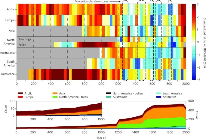
DOI https://doi.org/10.1038/ngeo1797 Abstract Past global climate changes had strong regional expression. To elucidate their spatio-temporal pattern, we reconstructed past temperatures for seven continental-scale regions during the past one to two millennia. The most coherent feature in nearly all of the regional temperature reconstructions is a long-term cooling trend, which ended late in the nineteenth century. At multi-decadal to centennial scales, temperature variability shows distinctly different regional patterns, with more similarity within each hemisphere than between them. There were no globally synchronous multi-decadal warm or cold intervals that define a worldwide Medieval Warm Period or Little Ice Age, but all reconstructions show generally cold conditions between AD 1580 and 1880, punctuated in some regions by warm decades during the eighteenth century. The transition to these colder conditions occurred earlier in the Arctic, Europe and Asia than in North America or the Southern Hemisphere regions. Recent warming reversed the long-term cooling; during the period AD 1971–2000, … WeiterlesenContinental-scale temperature variability during the past two millennia
DOI https://doi.org/10.1016/j.tecto.2011.11.019 We image the east- and westward extent of a crustal high-velocity body, the thickness of a layered sequence around the Moho at the flank of the body, and the uppermost mantle velocity along the 320 km long refraction and wide-angle reflection seismic profile ESTRID 2007 in the Danish Basin. Ray-tracing modelling of the seismic data reveals a high-velocity body (6.7-7.7 km/s between 10 and 30 km depth) with a lateral extent of at least 110 km. It is interpreted as an intrusive body of gabbroic composition. Moho depth is variable between 30 and 35 km along the profile. The crust is thin in a similar to 180 km wide zone approximately below the western part of the intrusive body and further westward in the basin area. The Pn velocity in the uppermost mantle is relatively low (similar to 7.8 km/s) beneath the thin crust whereas higher Pn velocities … WeiterlesenSeismic velocity structure of crustal intrusions in the Danish Basin
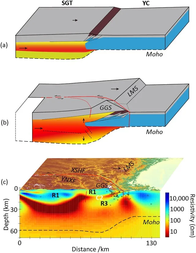
DOI http://dx.doi.org/10.1029/2021GL097394 Abstract Plain Language Summary Continent‐continent collisions are an important tectonic process and have controlled the formation of the modern continents. The India‐Asia collision is the best modern example and has produced both a high elevation plateau and the world’s highest mountain belts. A range of tectonic processes occurs during these collisions as the crust deforms including extrusion and perhaps crustal flow. Within these collision zones, there are locations of especially rapid uplift that have not been explained with existing geodynamic models. This paper investigates this process through a study of Gongga Shan—a mountain on the eastern edge of the Tibetan Plateau, where uplift continues at a rate of 2–3 mm per year and has formed peaks greater than 7,500 m in elevation. 3D inversion of an array of magnetotelluric data has produced a well‐constrained crustal resistivity model for the GGS area. It reveals that the GGS crust is … WeiterlesenMechanism for the Uplift of Gongga Shan in the Southeastern Tibetan Plateau Constrained by 3D Magnetotelluric Data
DOI https://doi.org/10.1038/nature06379 Abstract The process of continental break-up provides a large-scale experiment that can be used to test causal relations between plate tectonics and the dynamics of the Earth’s deep mantle1,2. Detailed diagnostic information on the timing and dynamics of such events, which are not resolved by plate kinematic reconstructions, can be obtained from the response of the interior of adjacent continental plates to stress changes generated by plate boundary processes. Here we demonstrate a causal relationship between North Atlantic continental rifting at ∼62 Myr ago and an abrupt change of the intra-plate deformation style in the adjacent European continent. The rifting involved a left-lateral displacement between the North American-Greenland plate and Eurasia, which initiated the observed pause in the relative convergence of Europe and Africa3. The associated stress change in the European continent was significant and explains the sudden termination of a ∼20-Myr-long contractional intra-plate deformation within Europe4, during the late Cretaceous … WeiterlesenDynamics of Mid-Palaeocene North Atlantic rifting linked with European intra-plate deformations
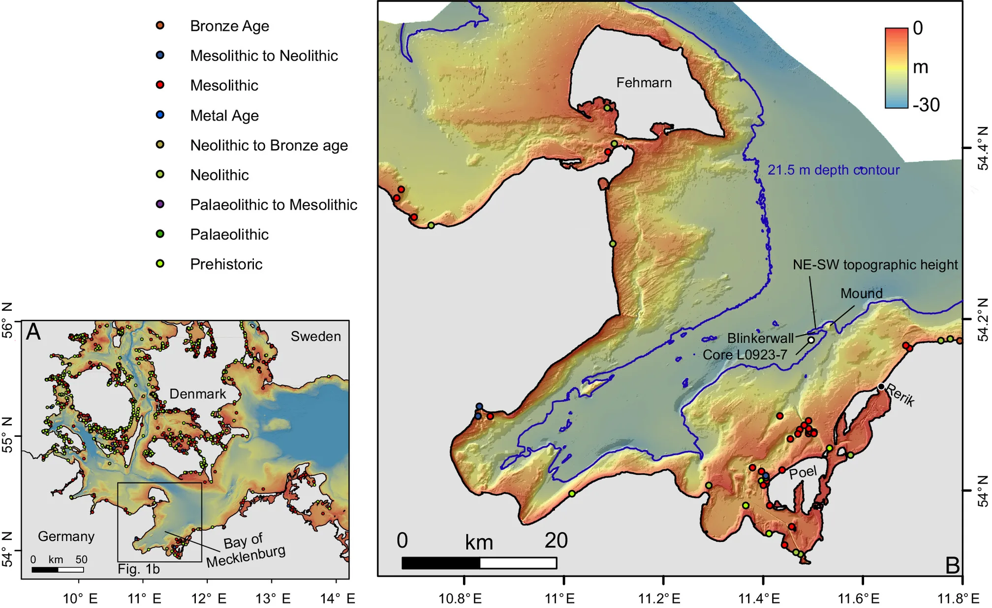
DOI https://doi.org/10.1073/pnas.2312008121 Abstract The Baltic Sea basins, some of which only submerged in the mid-Holocene, preserve Stone Age structures that did not survive on land. Yet, the discovery of these features is challenging and requires cross-disciplinary approaches between archeology and marine geosciences. Here, we combine shipborne and autonomousunderwater vehicle hydroacoustic data with up to a centimeter range resolution, sedimentological samples, and optical images to explore a Stone Age megastructure located in 21 m water depth in the Bay of Mecklenburg, Germany. The structure is made of 1,673 individual stones which are usually less than 1 m in height, placed side by side over a distance of 971 m in a way that argues against a natural origin by glacial transport or ice push ridges. Running adjacent to the sunken shoreline of a paleolake (or bog), whose youngest phase was dated to 9,143 ±36 ka B.P., the stonewall was likely used … WeiterlesenA submerged Stone Age hunting architecture from the Western Baltic Sea